O linie · șapte sanctuare · 4.255 kmOne line · seven sanctuaries · 4,255 km

SPADA
ARHANGHELULUI
THE ARCHANGEL'S
SWORD

Din Atlantic până la Muntele Carmel, șapte sanctuare ale Arhanghelului Mihail stau pe o linie cu azimut constant. Legenda spune că e urma sabiei lui. Măsurătoarea spune altceva, și e aproape la fel de stranie.From the Atlantic to Mount Carmel, seven sanctuaries of the Archangel Michael sit on a line of constant bearing. Legend calls it the mark of his sword. The measurement says something else, and it is nearly as strange.

7sanctuaresanctuaries
4.255 km4,255 kmSkellig → CarmelSkellig → Carmel
S 60,42° ES 60.42° Eazimut constantconstant bearing
± 19 kmabatere maximă, recalcul propriumax deviation, our recalculation

I · LegendaI · The legend

TăieturaThe cut

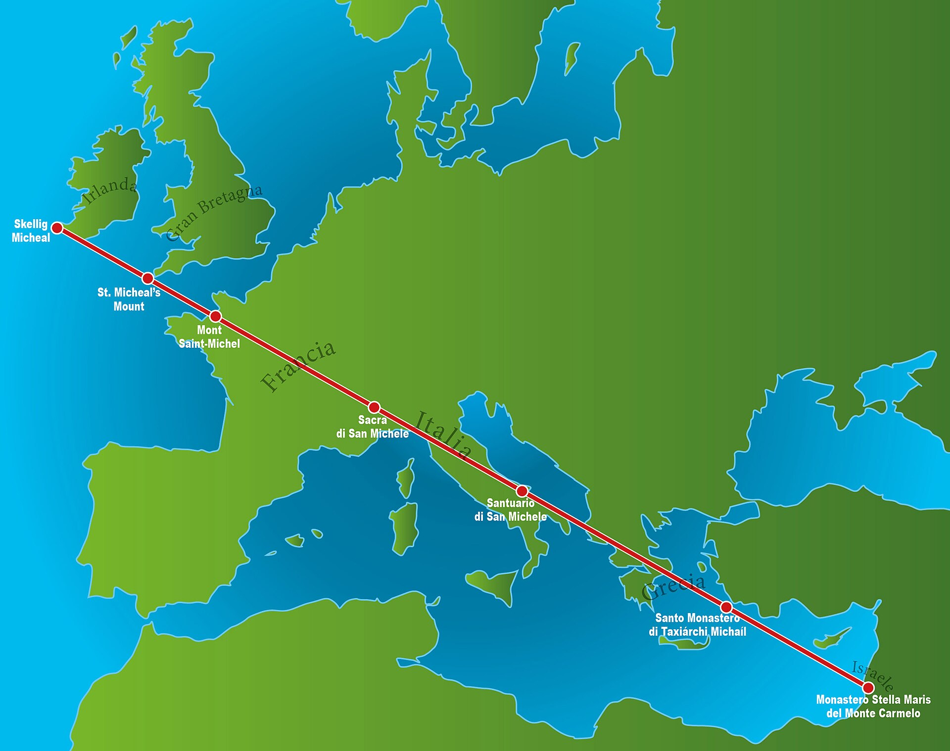
Hartă orientativă a Liniei Sfântului Mihail, cu sanctuarele de la Skellig Michael la Muntele Carmel.
Linia Sfântului Mihail, în forma ei populară: șapte sanctuare atribuite Arhanghelului Mihail, de la Skellig Michael la Muntele Carmel. Articolul de față verifică această hartă cu coordonate, distanțe și abateri.Saint Michael's Line, in its popular form: seven sanctuaries associated with the Archangel Michael, from Skellig Michael to Mount Carmel. This article checks that map against coordinates, distances and deviations.

Când Lucifer a căzut, spune legenda, Mihail a lovit cu sabia, iar tăietura a rămas în pământ: o linie dreaptă din Irlanda până în Țara Sfântă, pe care oamenii au ridicat, secol după secol, sanctuare închinate arhanghelului. Toate stau pe înălțimi greu de atins: stânci în ocean, insule mareice, vârfuri de munte, o peșteră în calcar. Versiunea care circulă azi, popularizată de Aleteia în mai 2017 și preluată de atunci în mii de pagini de pelerinaj, adaugă două detalii: cele trei mari sanctuare ar fi perfect echidistante, iar linia s-ar alinia cu apusul solstițiului de vară.

Ce verifică harta din povestea asta? Mai mult decât ar paria un sceptic. Mai puțin decât speră un pelerin. Pagina de față ia legenda în serios exact atât cât ia și geodezia: am refăcut calculul liniei din coordonatele publice ale celor șapte sanctuare, iar rezultatele sunt mai jos, cu tot cu metodă.

When Lucifer fell, the legend says, Michael struck with his sword, and the cut stayed in the earth: a straight line from Ireland to the Holy Land, along which people raised, century after century, sanctuaries to the archangel. All of them stand on hard-to-reach heights: ocean rocks, tidal islands, mountain summits, a limestone cave. The version in circulation today, popularised by Aleteia in May 2017 and repeated since across thousands of pilgrimage pages, adds two details: the three great sanctuaries are said to be perfectly equidistant, and the line is said to align with the summer solstice sunset.

How much of that story does the map confirm? More than a sceptic would bet. Less than a pilgrim hopes. This page takes the legend exactly as seriously as it takes geodesy: we re-derived the line from the seven sanctuaries' public coordinates, and the results are below, method included.

II · Cele șapte trepteII · The seven stations

De la ocean la deșertFrom ocean to desert

De la nord-vest spre sud-est, în ordinea în care le taie linia. Distanțele sunt măsurate pe loxodromă, de la stația precedentă.North-west to south-east, in the order the line crosses them. Distances are measured along the rhumb line, from the previous station.

KM 0

Skellig Michael

51°46′N 10°32′V · Kerry, IrlandaKerry, Ireland

Mănăstire din secolele VI-VIII pe o stâncă în Atlantic, cu chilii de piatră în formă de stup, terasate pe pante aproape verticale. Patrimoniu UNESCO din 1996. Legenda spune că Mihail i s-ar fi arătat aici Sfântului Patrick, ca să-l ajute să scape Irlanda de diavol.

A monastery of the 6th-8th centuries on an Atlantic rock, its beehive stone cells terraced on near-vertical slopes. UNESCO-listed since 1996. Legend has Michael appearing here to Saint Patrick, helping him rid Ireland of the devil.

În dosar: închinarea către Mihail e atestată abia din secolul X, la cel puțin două secole după întemeiere.On file: the dedication to Michael is attested only from the 10th century, at least two hundred years after the foundation.

+399 KM

St Michael's Mount

50°07′N 5°29′V · Cornwall, AngliaCornwall, England

Insulă mareică legată de țărm printr-un dig pietruit, vizibil doar la reflux; capelă atestată din secolul VIII, biserica actuală din secolul XIV. Tradiția locală spune că arhanghelul s-ar fi arătat unor pescari, în jurul anului 495, călăuzindu-i prin ape periculoase.

A tidal island joined to the shore by a cobbled causeway visible only at low tide; a chapel attested from the 8th century, the present church from the 14th. Local tradition has the archangel appearing to fishermen around the year 495, guiding them through dangerous waters.

În dosar: apariția e tradiție locală, fără izvor contemporan păstrat.On file: the apparition is local tradition, with no surviving contemporary source.

+331 KM

Mont-Saint-Michel

48°38′N 1°31′V · Normandia, FranțaNormandy, France

Episcopul Aubert de Avranches ridică un oratoriu pe stânca Mont-Tombe în 708, după trei vise în care arhanghelul i-ar fi cerut-o; la al treilea, Mihail și-ar fi apăsat degetul în craniul episcopului sceptic. Craniul lui Aubert, cu adâncitura lui cu tot, se păstrează ca relicvă la Avranches. Abația e patrimoniu UNESCO din 1979.

Bishop Aubert of Avranches raised an oratory on the rock of Mont-Tombe in 708, after three dreams in which the archangel demanded it; at the third, Michael is said to have pressed a finger into the sceptical bishop's skull. Aubert's skull, dent included, is kept as a relic at Avranches. The abbey has been a UNESCO site since 1979.

În dosar: data de 708 e solidă; visele și degetul sunt hagiografie.On file: the date of 708 is solid; the dreams and the finger are hagiography.

+779 KM

Sacra di San Michele

45°06′N 7°21′E · Piemont, ItaliaPiedmont, Italy

Abație ridicată între 983 și 987 pe vârful muntelui Pirchiriano, la 962 m, deasupra văii Susei. Aici apare singura intenție documentată de pe toată linia: surse italiene susțin că Sacra a fost așezată deliberat la jumătatea drumului de pelerinaj dintre Mont-Saint-Michel și Gargano, pe Via Sancti Michaelis. Măsurat azi: 779 km într-o parte, 791 km în cealaltă.

An abbey raised between 983 and 987 on the summit of Mount Pirchiriano, at 962 m above the Susa valley. Here sits the only documented intention on the whole line: Italian sources hold that the Sacra was deliberately sited halfway along the pilgrimage road between Mont-Saint-Michel and Gargano, the Via Sancti Michaelis. Measured today: 779 km one way, 791 km the other.

În dosar: legenda îi atribuie construcția îngerilor, care ar fi cărat pietrele peste noapte.On file: legend credits the construction to angels, said to have carried the stones overnight.

+791 KM

Monte Sant'Angelo

41°43′N 15°57′E · Gargano, ItaliaGargano, Italy

Grota în care Mihail s-ar fi arătat în 490: cel mai vechi sanctuar al arhanghelului din Europa de Vest, singurul despre care tradiția spune că a fost sfințit de arhanghel însuși, fără rit omenesc. Legenda fondatoare are un taur rătăcit, o săgeată care se întoarce împotriva trăgătorului și trei viziuni ale episcopului de Siponto. Din 2011, parte din situl UNESCO „Longobarzii în Italia".

The cave where Michael is said to have appeared in 490: Western Europe's oldest sanctuary of the archangel, and the only one tradition says was consecrated by the archangel himself, with no human rite. The founding legend has a stray bull, an arrow that turns back on its archer, and three visions granted to the bishop of Siponto. Since 2011, part of the UNESCO site "Longobards in Italy".

În dosar: grota fusese loc de cult păgân, legat de oracole și de Calchas, înainte de consacrarea creștină.On file: the cave had been a pagan cult site, tied to oracles and to Calchas, before its Christian consecration.

+1.174 KM

Panormitis

36°33′N 27°51′E · Symi, GreciaSymi, Greece

Mănăstire ortodoxă într-un golf închis din sudul insulei Symi, în Dodecanez; clădirile actuale, văruite în alb în jurul unei clopotnițe baroce, sunt din secolul XVIII, pe tradiții bizantine mai vechi și, se spune, peste un templu elenistic. Mihail e aici taxiarhul, patronul marinarilor: legendele vorbesc de corăbii ținute în loc de jurăminte neîmplinite și de sticle cu rugăciuni aduse de curent înapoi la țărm.

An Orthodox monastery on a sheltered bay in the south of Symi, in the Dodecanese; the present whitewashed buildings around a baroque bell tower date from the 18th century, on older Byzantine traditions and, it is said, over a Hellenistic temple. Michael is the taxiarch here, patron of sailors: the legends tell of ships held in port by unfulfilled vows, and of prayer bottles carried back to shore by the current.

În dosar: dintre cele șapte, e sanctuarul cu abaterea cea mai mare spre sud față de linie: 19 km.On file: of the seven, this is the sanctuary that strays furthest south of the line: 19 km.

+772 KM

Stella Maris

32°50′N 34°58′E · Muntele Carmel, IsraelMount Carmel, Israel

Mănăstire carmelitană pe creasta Carmelului, deasupra Haifei; eremiții care au întemeiat ordinul s-au așezat pe munte în secolul XII, iar clădirea actuală e din 1836. Muntele e al profetului Ilie, cel care i-a înfruntat aici pe profeții lui Baal.

A Carmelite monastery on the ridge of Carmel, above Haifa; the hermits who founded the order settled on the mountain in the 12th century, and the present building dates from 1836. The mountain belongs to the prophet Elijah, who faced down the prophets of Baal here.

În dosar: detaliul incomod al întregii povești. Nu există nicio legătură istorică sau mitică documentată între acest loc și Mihail; singura punte e o legendă populară ucraineană, în care arhanghelul îi dă tunetul lui Ilie ca armă împotriva lui Baal.On file: the awkward detail of the whole story. No documented historical or mythic link exists between this place and Michael; the only bridge is a Ukrainian folk legend, in which the archangel gives Elijah thunder as a weapon against Baal.

III · Masa cartografuluiIII · The cartographer's desk

Cât de dreaptă e, de fapt, liniaHow straight the line really is

O loxodromă e drumul pe care îl ții când nu schimbi niciodată azimutul: tai fiecare meridian sub același unghi. Pe glob se încolăcește încet spre pol; pe o hartă Mercator devine linie perfect dreaptă. Navigatorii o folosesc de cinci secole tocmai pentru asta, iar o busolă de relevment și un instrument de vizare erau suficiente pentru a o trasa și în Antichitate.

În 2016, astrofizicianul Luca Amendola a calculat loxodroma optimă prin sanctuarele lui Mihail și prin sanctuarele lui Apollo din axa propusă de Jean Richer: azimut 60,45°, abatere medie 14 km, maximă 42 km, pe circa 4.190 km. Am refăcut calculul doar pentru cele șapte sanctuare michaelice, din coordonatele lor publice: azimut S 60,42° E, abatere medie 10 km, abatere maximă 19 km, pe 4.255 km. Seturile de puncte diferă, concluzia coincide. Alinierea există. Rămâne de lămurit ce înseamnă.

A rhumb line, or loxodrome, is the path you hold when you never change bearing: you cross every meridian at the same angle. On the globe it slowly coils towards the pole; on a Mercator map it becomes a perfectly straight line. Sailors have used it for five centuries for exactly that reason, and a compass with a sighting instrument was enough to lay one out in antiquity too.

In 2016 the astrophysicist Luca Amendola computed the best-fit loxodrome through Michael's sanctuaries and the Apollo sanctuaries of Jean Richer's proposed axis: bearing 60.45°, mean deviation 14 km, maximum 42 km, over roughly 4,190 km. We re-ran the calculation for the seven Michaelic sanctuaries alone, from their public coordinates: bearing S 60.42° E, mean deviation 10 km, maximum deviation 19 km, over 4,255 km. The point sets differ; the conclusion coincides. The alignment exists. What it means is the part still open.

Coridorul · profilul abaterilorThe corridor · deviation profile

0/7în coridorinside
liniathe line +20 km−20 km 02.000 km4.255 km Skellig Mount M-S-Michel Sacra Gargano Panormitis Carmel
± 5 km

Verticala e exagerată de ~17 ori față de orizontală; pe o hartă nedeformată, abaterile ar fi invizibile. Lărgește coridorul până încap toate cele șapte.The vertical scale is exaggerated ~17× relative to the horizontal; on an undistorted map the deviations would be invisible. Widen the corridor until all seven fit.

La ±19 km, toate cele șapte sanctuare încap într-o fâșie de 38 km lățime, întinsă pe 4.255 km lungime. Proporțiile unui fir de ață de 2 mm, întins pe 22 de centimetri. Iar echidistanța celor trei mari sanctuare, cifra-vedetă a articolelor de pelerinaj, ține și ea la verificare: 779 km de la Mont-Saint-Michel la Sacra, 791 km de la Sacra la Gargano, o diferență de 1,5%. Doar valoarea care circulă, „1.000 km", e umflată.

At ±19 km, all seven sanctuaries fit inside a strip 38 km wide and 4,255 km long. The proportions of a 2 mm thread stretched across 22 centimetres. And the equidistance of the three great sanctuaries, the star figure of the pilgrimage articles, also survives checking: 779 km from Mont-Saint-Michel to the Sacra, 791 km from the Sacra to Gargano, a difference of 1.5%. Only the circulating value, "1,000 km", is inflated.

SanctuarSanctuaryCoordonateCoordinatesKm de la SkelligKm from SkelligAbatereDeviation
Skellig Michael51,771°N 10,540°V0+11 km N
St Michael's Mount50,117°N 5,478°V399−4 km S
Mont-Saint-Michel48,636°N 1,512°V731−3 km S
Sacra di San Michele45,098°N 7,343°E1.511+6 km N
Monte Sant'Angelo41,708°N 15,955°E2.301−10 km S
Panormitis36,550°N 27,846°E3.476−19 km S
Stella Maris32,826°N 34,969°E4.255+19 km N

Metodă: potrivirea loxodromei care minimizează abaterea pătratică medie, în proiecție Mercator, cu distanțele transversale scalate local; coordonatele sunt cele publice ale fiecărui sit. Calcul reproductibil din cifrele de mai sus.Method: fit of the loxodrome minimising mean square deviation, in Mercator projection, with cross-track distances scaled locally; coordinates are each site's public ones. Reproducible from the figures above.

IV · DosarulIV · The dossier

Ce ține și ce nuWhat holds and what doesn't

confirmatconfirmedCele șapte sanctuare există, cu întemeieri documentate între secolul V (Gargano, ~490) și 1836 (Stella Maris). O loxodromă de azimut ~60° trece la cel mult 19 km de fiecare, iar cele trei mari sanctuare sunt echidistante cu o abatere de 1,5%.The seven sanctuaries exist, with documented foundations between the 5th century (Gargano, c. 490) and 1836 (Stella Maris). A loxodrome of ~60° bearing passes within 19 km of each, and the three great sanctuaries are equidistant to within 1.5%.

solid, publicsolid, publicÎntre Mont-Saint-Michel și Gargano a funcționat în Evul Mediu un drum de pelerinaj, Via Sancti Michaelis, cu biserici michaelice de-a lungul lui; surse italiene susțin că Sacra a fost ridicată deliberat la mijlocul lui. Dacă e așa, aceasta e singura porțiune a liniei construită demonstrabil cu intenție.A medieval pilgrimage road, the Via Sancti Michaelis, ran between Mont-Saint-Michel and Gargano, with Michaelic churches along it; Italian sources hold that the Sacra was deliberately raised at its midpoint. If so, this is the only stretch of the line demonstrably built with intent.

solid, publicsolid, publicLinia, ca idee, e modernă. Jean Richer publică în 1967 alinierea templelor lui Apollo (Kerkyra, Delfi, Atena, Delos); fratele lui o prelungește în 1977 spre vest și est și o numește axa Mihail-Apollo. Viralizarea vine în 2017, printr-un articol Aleteia preluat apoi de presa catolică din zeci de țări.The line, as an idea, is modern. Jean Richer published the alignment of Apollo's temples (Corfu, Delphi, Athens, Delos) in 1967; his brother extended it west and east in 1977 and named it the Michael-Apollo axis. Virality arrived in 2017, through an Aleteia article picked up by Catholic media in dozens of countries.

legendălegendTăietura sabiei la căderea lui Lucifer; aparițiile fondatoare (taurul și săgeata din Gargano, visele lui Aubert, pescarii din Cornwall, pietrele cărate de îngeri la Sacra); tunetul dat lui Ilie pe Carmel. Conținut devoțional, nu probă.The sword-cut at Lucifer's fall; the founding apparitions (the bull and arrow of Gargano, Aubert's dreams, the Cornish fishermen, the angel-carried stones of the Sacra); the thunder given to Elijah on Carmel. Devotional content, not evidence.

neverificatunverifiedAlinierea cu apusul solstițiului de vară, citată în lanț din site-uri de turism, fără un calcul astronomic publicat. Direcția nord-vest a liniei e în zona bună de azimut, dar azimutul apusului variază cu latitudinea de-a lungul celor 4.255 km, deci afirmația cere o demonstrație pe care nimeni nu a dat-o.The alignment with the summer solstice sunset, cited in a chain of travel sites, with no published astronomical calculation. The line's north-west direction is in the right azimuth range, but sunset azimuth varies with latitude along the 4,255 km, so the claim needs a demonstration nobody has provided.

disputatdisputedIntenția. Europa are sute de lăcașuri închinate lui Mihail, iar cu atâtea puncte pe hartă, alinieri apar oricum; istoricii tratează linia întreagă drept construcție retroactivă, în siajul modei ley lines pornite de Alfred Watkins în anii 1920. Capetele sunt cele mai slabe: Skellig primește hramul abia în secolul X, iar Carmelul nu are nicio legătură atestată cu arhanghelul. Nimeni nu a publicat însă calculul care să arate cât de probabilă e, prin simplu hazard, o aliniere atât de strânsă. Scepticii au un argument bun și nicio cifră; credincioșii au o cifră bună și niciun document.Intent. Europe has hundreds of churches dedicated to Michael, and with that many points on the map, alignments appear regardless; historians treat the full line as a retroactive construction, in the wake of the ley-line fashion started by Alfred Watkins in the 1920s. The endpoints are the weakest: Skellig received its dedication only in the 10th century, and Carmel has no attested link to the archangel at all. Yet nobody has published the calculation showing how likely an alignment this tight is by pure chance. The sceptics have a good argument and no number; the believers have a good number and no document.

V · Întrebări deschiseV · Open questions

Ce ar schimba evaluareaWhat would change the assessment

  • Niciun text medieval cunoscut nu pomenește linia întreagă. Un singur document care ar lega, înainte de secolul XX, mai mult de două sanctuare într-o geometrie comună ar răsturna întreaga discuție.No known medieval text mentions the full line. A single document linking more than two sanctuaries into a shared geometry before the 20th century would overturn the whole debate.
  • Testul statistic lipsește. Cu baza de date a tuturor sanctuarelor michaelice majore din Europa și o simulare Monte Carlo, întrebarea „cât de rar e ±19 km?" are un răspuns numeric. Nu l-a calculat nimeni, în nicio tabără.The statistical test is missing. With a database of every major Michaelic sanctuary in Europe and a Monte Carlo simulation, the question "how rare is ±19 km?" has a numerical answer. Nobody, in either camp, has computed it.
  • Selecția e retroactivă: cele șapte au fost alese dintr-o mulțime mult mai mare de situri michaelice, după criteriul că stau pe linie. E definiția erorii țintașului texan, iar singurul antidot e refacerea calculului cu toate siturile majore, convenabile sau nu.The selection is retroactive: the seven were picked from a much larger population of Michaelic sites, on the criterion that they sit on the line. That is the textbook Texas sharpshooter effect, and the only antidote is re-running the calculation with every major site, convenient or not.
  • Capătul estic e șubred. Fără Stella Maris, „spada" se oprește la Symi și pierde 772 km și toată simbolistica Țării Sfinte. Cine a ales Carmelul drept vârf al spadei, și pe ce temei, rămâne nedocumentat.The eastern end is shaky. Without Stella Maris, the "sword" stops at Symi and loses 772 km along with all the Holy Land symbolism. Who chose Carmel as the sword's point, and on what basis, remains undocumented.

Pe hartă, linia ține. În arhive, se desface: un drum medieval real la mijloc, două capete adăugate târziu, o legendă care le sudează. Poate că asta e anatomia oricărui mit reușit: câteva fapte tari, întinse pe patru mii de kilometri de dorință.On the map, the line holds. In the archives, it comes apart: a real medieval road in the middle, two ends added late, a legend welding them together. Perhaps that is the anatomy of every successful myth: a few hard facts, stretched across four thousand kilometres of longing.

Marius Comper · iunie 2026June 2026

VI · SurseVI · Sources

Dosarul de lucruThe working file

Documente și instituțiiDocuments and institutions

Analiză și verificareAnalysis and verification

  • Wikipedia · Saint Michael's line · sinteza critică; tot acolo e citat Luca Amendola, „Luke Skywalker and the St. Michael Axis" (2016), al cărui original supraviețuiește doar în arhivă web· the critical synthesis; it also cites Luca Amendola, "Luke Skywalker and the St. Michael Axis" (2016), whose original survives only in web archive
  • Recalcul propriu (2026): potrivire de loxodromă pe coordonatele publice ale celor șapte sanctuare; metoda și cifrele complete sunt în secțiunea III, reproductibileOur recalculation (2026): loxodrome fit on the seven sanctuaries' public coordinates; method and full figures in section III, reproducible
  • GREtour · St Michael's Line: Earth Energies or Coincidence? · rezumat al poziției sceptice· summary of the sceptical position

Presă și pelerinajPress and pilgrimage

Notă de onestitate: coordonatele și datele de întemeiere ale sanctuarelor provin din fișele publice ale fiecărui sit și din sinteza Wikipedia; acolo unde un fapt stă pe o singură sursă (amplasarea deliberată a Sacrei, hramul târziu de la Skellig), textul o spune explicit.Honesty note: the sanctuaries' coordinates and foundation dates come from each site's public records and from the Wikipedia synthesis; wherever a fact rests on a single source (the Sacra's deliberate siting, Skellig's late dedication), the text says so explicitly.